Map Editor User Guide - Projections
|
Installation Feature LayerStyles Effects Drop Shadow |
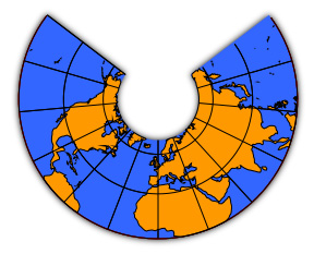
Projections are used to draw the Earth's surface on a plane. When the map's coordinates system is latitude/longitude, you can set a viewing projection in order to view your map with minumum (or maximum) distortion. Projections also form the basis of coordinate systems. Built in projections include Transverse Mercator, Lambert Conformal Conic and Plate Carrée, but many other projections are available as plugins. Warning: the support for projections in the map viewer could best be described as "experimental". There are many limitations and bugs which will be fixed as time allows.
The Lambert Conformal Conic Projection To set a map projection, you must first make sure that you map is using the Latitude/Longitude coordinate system. You can do this in the "Map Properties" dialog, available in the "Map" menu. When you have done this, choose "Set Projection..." from the view menu. This shows a dialog which allows you to choose a map projection and change some of its parameters. Warning: changing the parameters is best avoided at present - many changes will produce garbage maps. When you create a new map, the projection in effect is "Linear" which does not map coordinates at all. A good map projection to start with is "Plate Carrée". This is hardly a "real" projection at all but simply maps latitude/longitude linearly into X/Y. The difference between this and "Linear" is that the Earth's radius is now taken into account and you'll find that your map suddenly gets much bigger. Choose "Zoom to Fit" to fit your map to the window again and then you can choose another projection to compare. |