Map Editor User Guide - Rendering Maps
|
Installation Feature LayerStyles Effects Drop Shadow |
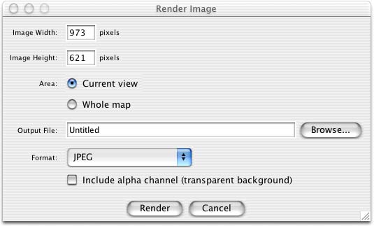
IntroductionIf you want an image of all or part of your map, such as for use in a web site, you need to render it. The Map Viewer can render maps in a variety of image formats, such as JPEG, BMP and TIFF. Extra file formats can be added as plugins. Rendering a MapTo render a map, invoke the "Render..." command from the File menu. This shows the dialog below:
The Render Dialog You may choose to render the whole map or just the part of it visible in the current view. In both cases, the Map Viewer will try to fit the area you choose to the image size to select without changing the map's aspect ratio. If the image aspect ratio is different from the area aspect ratio, you will have extra parts of the map rendered to fill in the gaps. Image ExportersImage exporting is implemented by plugins called image exporters. By default, Map Viewer comes with just a JPEG image exporter, but more can be added via plugins. The JIMI plugin set adds support for: Photoshop, Portable Network Graphics, Windows BMP, Targa, PCX, and XPM file formats. The JAI plugin set adds support for: TIFF, Windows BMP, FlashPix and PNG (Portable Network Graphics).
|